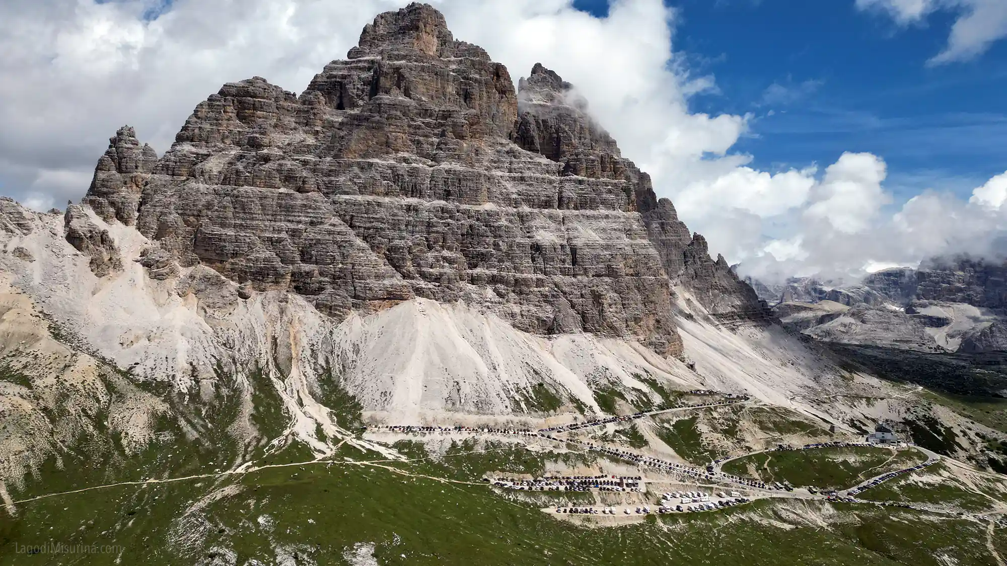
Three weeks ago I met a couple who had just finished the Tre Cime loop. They had started at eleven in the morning, in August, without booking parking. They spent forty minutes finding a spot, another thirty in line for the shuttle, and then four and a half hours to complete a trail that on paper takes three. When I saw them they were exhausted, disappointed, and kept repeating “but they told us it was easy”.
The Tre Cime di Lavaredo loop is technically a medium difficulty hike. Nine and a half kilometers, four hundred meters of elevation gain, three hours and fifteen minutes if you walk at a steady pace. On paper it’s doable for anyone with minimal fitness. In reality, it depends on when you start, how you arrive, and what you expect to find.
After twenty years, I’ll tell you something: the Tre Cime loop can be an extraordinary experience or a frustrating day. The difference isn’t in the trail, it’s in how you organize yourself.

What the Tre Cime are and why everyone wants to go there
The Tre Cime di Lavaredo are three vertical rock walls that emerge from the Dolomite landscape like stone fingers. Cima Grande (2999 meters), Cima Ovest (2973 meters), Cima Piccola (2857 meters). They’ve become the symbol of the Dolomites, recognized as UNESCO World Heritage, and appear on thousands of photos, postcards, tourist posters.
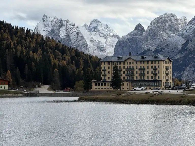
The reason everyone wants to see them is simple: they are objectively impressive. Three north faces rising against the sky, with that unmistakable shape you recognize even from afar. But there’s a difference between seeing them from Misurina with binoculars and walking around them at their base. And that difference is called “the Tre Cime loop trail”.
The trail winds through the Tre Cime Natural Park, established in 1981, covering almost twelve thousand hectares between the provinces of Belluno and Bolzano. It’s a protected area where you find alpine flora, chamois, marmots, and if you’re lucky some eagles circling above the ridges. The landscape changes at every turn of the trail: white scree, alpine meadows, hidden lakes, rocks shaped by time.
But what makes this place special isn’t just nature. It’s also history. During World War I there was fighting here, and along the trail you still find traces of that period: trenches, positions, and monuments that remember what happened on these mountains. Most people pass by without stopping, but if you take the time to look, you understand you’re walking on a piece of European history.
🏆 If you’d rather walk the loop with someone who knows every stone of it: on the guided Tre Cime di Lavaredo hike a local guide handles pace, logistics and the stories the trail doesn’t tell on its own. Check availability on GetYourGuide.
This article contains affiliate links: if you book through them, I earn a small commission at no extra cost to you.
The trail: what you need to know before starting
The Tre Cime di Lavaredo loop is a circuit that starts and ends at Rifugio Auronzo, at 2320 meters altitude. Total length: about 9.5-10 kilometers, depending on which variant you take. Elevation gain: 400 meters up, 400 down. Hiking time: three hours and fifteen minutes if you walk without ever stopping, four hours if you stop sometimes to look at the scenery, five or six hours if you start at the wrong time and find too many people.
The main trail is number 101, which takes you from Rifugio Auronzo to Forcella Lavaredo passing by Rifugio Lavaredo. From there continue on trail 105 and then on the Dolomites High Route number 4, passing by Rifugio Locatelli, Malga Lange, and finally returning to the starting point through Forcella di Mezzo.
It’s a marked trail, well-trodden, with clear signs. You won’t get lost unless you’re completely distracted. The surface is mixed: sections on white scree, others on meadow, others on rock. There are some exposed passages but never dangerous, and no equipped sections requiring harness or helmet.
On paper, I repeat, it’s accessible to everyone. In practice, there are details that make the difference.

From Rifugio Auronzo to Forcella Lavaredo
The first section is a gradual climb of about an hour and a half along trail 101. You start from Rifugio Auronzo, pass by the chapel of Maria Ausiliatrice (which many ignore, but worth a stop), and continue toward Rifugio Lavaredo at 2344 meters. The landscape here is open, with the Tre Cime dominating on your right. If you start early in the morning the light is perfect, with the sun illuminating the north faces laterally. If you look in the valley to your right, there are often marmots playing in the meadow, among the writings with stones.
From Rifugio Lavaredo you continue toward Forcella Lavaredo, at 2454 meters. It’s the highest point of the loop, and from here the view changes completely. You find yourself between the Tre Cime and Monte Paterno, with a 360-degree panorama that also includes the Sesto Dolomites in the distance. This is the first point where people stop for a long time for photos, and in high season it can become a bottleneck of people with tripods and selfie sticks.
The climb isn’t technically difficult, but you feel the altitude. If you live in the plains and aren’t used to walking above two thousand meters, you breathe faster and your legs feel heavier. It’s not a problem if you take your pace, it becomes a problem if you think you can run like in the city.

From Forcella Lavaredo to Rifugio Locatelli
From Forcella Lavaredo you descend slightly and continue on trail 105, which runs along the south side of the Tre Cime. This is the most spectacular section of the loop. The rock walls are just meters from you, and you realize the real dimensions of these mountains. You walk on white scree that crunches under your feet, with Monte Paterno on the left seeming to watch over everything.
After about forty minutes you arrive at Rifugio Locatelli, at 2405 meters. This is the strategic point of the entire loop: frontal view of the Tre Cime, meadows to sit on, and a hut where you can stop to eat something. The problem is everyone knows it, and in summer the hut is full from morning to evening. If you want to sit inside you have to wait, if you want to have lunch you need to book.
I recommend bringing something to eat in your backpack and stopping on the meadows around the hut. Same view, no queue, and you save money too… Remember that you must leave the mountain as you found it: clean! Trash goes back down to the valley, always.

From Rifugio Locatelli to Malga Lange and Return
From Rifugio Locatelli you continue downhill toward Malga Lange, at 2232 meters. The trail descends gently through alpine meadows and small lakes. This section is the quietest of the loop, less crowded and more relaxing. Malga Lange is another point where you can stop, but it’s much smaller and simpler than Rifugio Locatelli.
During this section of the trail, you can stop in the caves to take this “iconic photo” where the Tre Cime di Lavaredo seem to be photographed through a hole in the rock. Actually the photo is taken from inside a cave right near Rifugio Locatelli.
From here the trail climbs slightly toward Forcella di Mezzo and Col Forcellina, and then descends back to Rifugio Auronzo. The last section is quite monotonous: you walk on scree and stones, the Tre Cime are now behind you, and you just think about arriving. It takes about forty minutes, and if you’ve already walked for three and a half hours they seem long.
When you return to Rifugio Auronzo you’ve completed the loop. Ninety percent of people sit down, take off their shoes, and order something to drink. It’s the right time to do it. I usually close with a fresh, ice-cold beer.
How to reach Rifugio Auronzo (without going crazy)
Here’s the catch. The Tre Cime di Lavaredo loop starts from Rifugio Auronzo, at 2320 meters. To get there you have three options: on foot, by car or shuttle. All three have advantages and disadvantages, and if you don’t organize well you lose time and patience even before starting to walk.
Arriving on foot
This only applies if you’re fit, ready to walk for at least 6/7 hours. To reach the Tre Cime di Lavaredo on foot from Misurina, follow the trail that starts from Lake Antorno (about 8 km on foot, 2 and a half hours of walking), which will take you to Rifugio Auronzo. From here, start your loop around the Tre Cime. If it’s your first time in the area, start from my complete guide to Lake Misurina to get your bearings.
Arriving by car
A few minutes past Misurina you reach Lago d’Antorno, where the toll road begins: about six kilometres of climbing up to Rifugio Auronzo. It’s a narrow road, with continuous hairpin turns. Driving isn’t technically difficult, but requires attention. The toll costs 40 euros per car, 26 per motorbike and 60 for campers (2026 prices), the ticket is valid for 12 hours from your booked entry time, and it saves you the uphill walk compared to starting from Misurina on foot. Please note, access must be booked in advance, even for those with a disability permit. How the daily cap of 680 cars works, when the slots run out and what’s left if they do, I cover in full in the article on costs and booking for the Tre Cime car park.
The problem is parking. Rifugio Auronzo has limited parking, and in summer it fills up very early. If you arrive after nine you already find difficulties, if you arrive after ten thirty forget it. Or you wait for someone to free a spot, and it can take hours.
If you’d rather leave the car down in Misurina, I’ve covered all the car parks in Misurina with fees and tips — including the motorhome area and the best time to arrive — in a dedicated article.
In 2026 the toll road opens on May 23 and booking is mandatory for all cars, for the whole season: you book online on the official Auronzo.info portal, enter your number plate, and drive through an automated toll gate. I recommend booking at least a week in advance, especially if you come on weekends or in August. Without a booking they turn you back, and you’ve wasted the morning.
If you come in the quieter weeks – June, or from mid-September until the road closes in mid-October – the situation is more manageable. But parking is limited all season, so it’s still better to arrive early.
Arriving by shuttle
The alternative is the shuttle. The Dolomiti Bus shuttle departs from Misurina (Genzianella stop), calls at Lake Antorno and climbs to Rifugio Auronzo. In 2026 it runs daily from May 30, with departures roughly from 7:40 in the morning to the evening, and the day ticket costs 10 euros per person. You can buy it on the Dolomiti Bus app, at ticket offices or on board with contactless payment.
The advantage is you don’t have to drive, don’t have to worry about parking, and contribute to reducing traffic on the road. The disadvantage is that you must respect the schedules, and if you arrive at a peak time the shuttle may be full. In that case you wait for the next run, and lose more time.
From Dobbiaco there’s also bus 444, which climbs directly to Rifugio Auronzo — note that it doesn’t stop in Misurina, and in 2026 it requires online booking with advance payment. It works if you don’t have a car or want to do everything by public transport, but you need to plan the timetable carefully.
My practical advice
If you can choose, come by car, book parking online well in advance, and leave home so you arrive at Rifugio Auronzo by seven thirty in the morning. The easiest way to pull that off is sleeping ten minutes from the trailhead: I’ve explained how to pick the right place to sleep in Misurina in a dedicated guide. Starting early guarantees you a spot, avoids the crowds on the trail, and allows you to do the loop calmly truly enjoying the landscape.
If you can’t arrive so early, use the shuttle. At least you don’t stress about parking, and even if you arrive later at least you’re sure to get up there.
If you arrive after ten without booking and without shuttle, you’re approaching it wrong. Come back another day.
How difficult is it really
Everyone tells you that the Tre Cime loop is “of medium difficulty” or “suitable even for non-expert hikers”. It’s true, but with important clarifications.
The 400-meter elevation gain up and 400 down isn’t much, compared to other Dolomite hikes. The 9.5-kilometer length is manageable. But there are three factors that make the difference: altitude, duration, and physical fitness.
You feel the altitude
You start at 2320 meters and reach up to 2454 meters at Forcella Lavaredo. If you live in the plains and aren’t used to walking above two thousand meters, your body works harder. You breathe faster, your heart beats harder, and your legs tire sooner. It’s not dangerous, but it’s real.
My advice is to go slowly, especially in the first uphill section. Many start at a sustained pace as if they were on a hill trail, and after an hour they’re already worn out. Take your time, breathe, and stop when needed. It’s not a race.
Duration and endurance
Three hours and fifteen minutes is the theoretical duration, walking without stopping. In practice, with stops for photos, breaks, and maybe a longer stop at Rifugio Locatelli, it takes at least four hours. If you’re not fit or have small children, even five and a half.
Four hours of continuous walking require minimal physical endurance. You don’t need to be an athlete, but if the last hike you did was ten years ago, this isn’t the best one to start with. Better to do some shorter walks first to regain confidence.

Who it’s suitable for
The Tre Cime loop is suitable for anyone with minimal fitness and used to walking for a few hours. If you regularly do mountain walks, even of just a few hours, you won’t have problems. If you have children over ten who are used to walking, it’s doable. If you have good physical fitness but aren’t an experienced hiker, you’ll manage fine.
It’s not suitable for those who never walk, those with uncontrolled heart or respiratory problems, or small children who don’t walk for more than an hour. It’s not suitable for those who think they can do it with city sneakers, without water, and without knowing what to expect.
Easier variants
An option is to stop at Forcella Lavaredo and then turn back. You see the highest point, have the best view, and save two hours of walking. You don’t complete the loop, but see the best.
When to go (and when to avoid)
The ideal season for the Tre Cime loop goes from June to October. Before June there’s still snow on the trail, especially in shaded sections, and you need proper equipment. After October depends on the year, but generally conditions become more difficult and some huts close.
Summer (June-August)
Summer is the busiest period. Temperatures are mild, the trail is dry, the huts are all open. The problem is the crowds. In August, especially on weekends, the trail becomes a procession. You meet hundreds of people, the viewpoints are crowded, and the experience loses much of its charm.
If you must come in summer, choose June or the first days of July, when there are fewer people. Or come between September and mid-October, when schools have reopened and tourist flow drops dramatically.
Autumn (September-October)
For me the best period. Temperatures are cooler but still pleasant during the day, the colors of the mountain change completely, and above all there are many fewer people. The larches turn yellow, the air is clearer, and the light is perfect for photography.
The only disadvantage is that days are shorter, so you need to start earlier to have enough light. And the weather becomes more unstable, with possibility of sudden storms or early snow.
Ideal time
The best time to start is between six and seven in the morning. You arrive at Rifugio Auronzo with the sun just risen, start walking with perfect light, and when you arrive at Forcella Lavaredo it’s eight-nine. At that time you’re practically alone, or almost.
Starting after ten is a mistake, especially in summer. You already find many people on the trail, the sun is high and hot, and when you return to the parking lot in the early afternoon you’re tired and sweaty. Starting early completely changes the experience.
What to bring in your backpack
I’ve seen people start with a city backpack, a half-liter water bottle, and sneakers. And I’ve seen them return exhausted, dehydrated, with blisters on their feet. The right equipment isn’t optional, it’s necessary.
Shoes
Hiking boots with grippy soles. Not sneakers, not running shoes, not sandals. Real hiking boots, possibly already used on other occasions to avoid blisters. The trail has sections on scree, on rock, and some passages where you need stability. With wrong shoes you risk slipping or getting hurt.
Clothing
Even in summer, at 2400 meters the temperature can drop suddenly. Always bring a windproof jacket or fleece. The three-layer principle works well: breathable t-shirt, middle layer (fleece or sweatshirt), and waterproof jacket. So you can remove or add depending on conditions.
Long pants are better than shorts, especially if the trail is wet or there are insects. But if it’s hot, technical shorts are fine too, as long as they’re technical and not jeans.
Water and food
Bring at least one and a half liters of water per person, better two liters. Along the trail you can refill bottles at the huts, but fountains don’t always work and anyway it’s better to have autonomy. Dehydration at that altitude makes you feel bad much faster than in the plains.
For food, bring energy snacks: bars, dried fruit, chocolate. If you want to stop for a real lunch you can do it at Rifugio Locatelli, but it costs and you need to book. I always bring homemade meals, some cheese, and some apples. I eat on the meadows near the hut, spend zero, and feel better.
Other
Sunscreen, always. The sun at that altitude is much stronger and you burn in half an hour even with cloudy sky. Sunglasses. Hat. Trekking poles if you’re used to using them, they help in downhill sections.
And charged phone. It’s for photos, but also for safety. Signal is almost everywhere, but not guaranteed. If you have an offline maps app download the trail before starting.
The story they don’t tell you
Most people walk on the Tre Cime looking only at the mountains. It’s understandable, the landscape is spectacular. But if you look closer you realize you’re walking on a World War I battlefield.
Between 1915 and 1917 there was fighting here. The Cadore front crossed these mountains, with Italians on one side and Austro-Hungarians on the other. Soldiers living in trenches dug into the rock, at two thousand meters altitude, with cold, snow, and the enemy just meters away. Many didn’t die in combat, but from environmental conditions: freezing, avalanches, diseases.
The Warrior Angel
Along the trail, near the Piani di Lavaredo, there’s a two-and-a-half-meter tall statue representing a warrior angel. Many pass by without stopping, thinking it’s just a tourist monument. But it has a specific story.
The statue was commissioned by the commander of the 8th Bersaglieri regiment and created by Bersagliere Vittorio Morelli. It represents the spirit of the mountain watching over the fallen of all armies. The angel holds a sword piercing a serpent, symbol of victory over evil. It’s dedicated to all soldiers who died on these mountains, Italians and Austro-Hungarians together.
When I pass by I always stop for a few minutes. Not for rhetoric, but because it reminds me that this place isn’t just nature. It’s also memory. And it seems right to recognize it.
Traces of War
If you move just a few meters from the main trail, especially in the area of Monte Paterno and Piani di Lavaredo, you still find trenches, positions, remains of barracks. Some sections have been restored and made visitable, others are left as they were. You can enter a trench and imagine what it meant to stay there for months, with cold and fear.
Not everyone wants to stop to see these things, and that’s fine. But if you have time and interest, these places add a level of depth to the hike. It’s not just a scenic loop, it’s also a piece of European history.
What to do if something goes wrong
The mountain doesn’t forgive mistakes. I’m not saying this to scare you, but to make you understand that minimal preparation and awareness are needed.
Weather
Weather at altitude changes quickly. You can start with sun and find yourself in a storm an hour later. Before starting always check the forecast, and not generic ones, but those specific for mountains. If they forecast afternoon storms, start very early and return before they arrive.
If a storm catches you while on the trail, seek shelter in a hut or in a depression in the terrain. Don’t stay on ridges, don’t shelter under isolated trees, and move away from metal poles or exposed structures. Wait for it to pass, even if it takes hours. Better to arrive late than not arrive.
Injuries
If you get hurt or see someone in difficulty, call 112. Mountain rescue intervenes even for minor injuries, better to call before the situation worsens. Don’t improvise as a rescuer if you don’t know what to do, you can make things worse.
If you feel sick – severe headache, nausea, dizziness – stop immediately. It could be altitude sickness. Descend as soon as possible, even if it means interrupting the loop.
Orientation
The trail is well marked and you won’t get lost. But if for some reason you find yourself disoriented, stop and think. Look at the trail markers, check the map, and if in doubt go back to the last safe point. Don’t continue randomly hoping to find the trail again, in the mountains that doesn’t work well.
Other activities at the Tre Cime (if walking isn’t enough)
The loop trail is the main activity, but it’s not the only thing you can do in this area.
Mountain biking
From Dobbiaco starts a 25-kilometer mountain bike route with 1162 meters of elevation gain that reaches Rifugio Auronzo. It’s challenging, requires good legs and a suitable bike, but it’s one of the most beautiful routes in the Dolomites. If you’re an experienced cyclist and want to combine cycling up and then walking the loop, it’s doable. But prepare for a long and tiring day.
Snowshoeing (winter)
In winter, when snow covers everything, the Tre Cime loop can be done with snowshoes. It’s a completely different experience: total silence, white landscape, and almost no one around. It requires winter experience, proper equipment, and awareness of risks related to avalanches and weather conditions. Not for beginners, I recommend a guide even for experienced ones.
Climbing
The Tre Cime are also famous for climbing. There are over 25 routes on the three faces, some of which are among the most famous in the Alps. But this is territory for experts, with specific equipment and technical preparation. If you want to try, you can go to the climbing gym in Brunico, not here. It’s not something you improvise.
If you’re staying in the area for more than a day, the other classic hike is on the opposite side of the valley: I’ve written my honest guide to the Lake Sorapis hike, including the exposed sections that catch a lot of people off guard.
Questions I always get asked
Can I do the loop with children?
Depends on age and walking habits. With children over ten who walk regularly, yes. With younger children better the short variant to Rifugio Lavaredo. With children under six, I should tell you forget it, actually I did it.
Can I bring my dog?
Technically yes, but keep it on a leash and pick up droppings. Consider though that it’s 9.5 kilometers on rocky trail, and not all dogs can make it. If you have a small or elderly dog, leave it at home.
Is a guide necessary?
No. The trail is well marked and doesn’t require technical skills. A guide makes sense only if you want to deepen naturalistic, historical, or geological aspects.
How much does it cost?
The road toll is 40 euros per car (2026), the shuttle 10 euros per person with the day ticket. If you eat at the huts calculate 15-20 euros for a dish. If you bring food from home and use the shuttle, you spend little.
Is there phone coverage?
Yes, almost everywhere. But it’s not guaranteed at all points, especially in hollows or behind rocks. Download offline maps before starting.
Can I do the loop backwards?
Yes, but 90% of people do it counterclockwise (Rifugio Auronzo → Forcella Lavaredo → Rifugio Locatelli). Going in the opposite direction isn’t forbidden, but you’ll find the flow of people against you and it might be less comfortable.
The mistake everyone makes
There’s a mistake I see made continuously, and that ruins the experience for many people: arriving without preparing and thinking it’s enough to just show up.
The Tre Cime di Lavaredo loop has become so famous that many approach it with a tourist attitude, not a hiker’s. They arrive in flip-flops, without water, without checking the weather, without booking parking. And then they complain it’s difficult, there are too many people, it’s not what they expected.
The mountain requires respect. Not in the rhetorical sense, but in the practical sense. You need to inform yourself, prepare, bring the right equipment, and have minimal awareness of where you’re going. If you do, the Tre Cime loop is a beautiful experience. If you don’t, it becomes a tiring and frustrating day.
I’ve been there, in every season and with almost every type of weather. And I continue to find it spectacular. But only when done right, with the right timing, and with the respect it deserves.
Come prepared, start early, walk calmly. The rest comes by itself. And if in the afternoon your legs still work, the easy walk around Lake Misurina is the perfect way to wind down.
Updated: August 2026